Facility to be built facility with NOAA funds for creation of a new Center of Excellence for Operational Ocean and Great Lakes Mapping
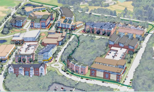
A rendering of one vision of The Edge, an academic, research, business and residential area on the University of New Hampshire Durham campus. (Courtesy photo) The University of New Hampshire is requesting proposals for initial development of The Edge, its ambitious academic, research, business and residential project on its Durham campus.
The request for proposals (RFPs) issued in late June deals specifically with the construction of a new, state-of-the-art facility in cooperation with the National Ocean and Atmospheric Administration (NOAA).
According to NOAA, the new facility will include office and instructional space, as well as a large, high-ceiling area with overhead cranes — known as a high bay — for storing, outfitting and staging bulky equipment and small vessels.
The facility will be built with a portion of $10 million funded to NOAA as it and UNH expand on what has been a 24-year long partnership through the creation of a new Center of Excellence for Operational Ocean and Great Lakes Mapping.
“NOAA’s Office of Coast Survey is excited to work with the University of New Hampshire as we develop and operate the Center of Excellence for Operational Ocean and Great Lakes Mapping,” said Rear Admiral Ben Evans, director of NOAA’s Office of Coast Survey.
“This Center will amplify our efforts to transition research to operations, provide technical support to our fleet, and generate, develop and diversify our mapping workforce, all in collaboration with our academic, public and private sector partners,” he added in a statement when the collaboration extension and facility were announced in September.
The RFP by UNH comes on the heels of a request for information (RFI), a part of the process to determine interest on a particular project by developers and other potential partners. The RFI was for the general concept of The Edge, described in the RFI as follows:
“The EDGE at UNH is a transformational opportunity to build an active neighborhood of innovation on the University of New Hampshire’s western edge, within steps of the UNH campus core. Entrepreneurs, researchers, students and established professionals will mingle and collaborate in this lively new district with eclectic restaurants, office buildings, hotel, research facilities, housing, shops and other amenities. The EDGE at UNH will be a live-work-play environment where academic and industry collaborators bring new technologies and products from idea to marketplace, generating economic value and job creation.”
With the RFI, the university said it sought “to gather general information, recommendations and shared experience from innovation communities that have been successfully planned and implemented across the country in a similar setting.”
The RFI deadline was in April, and Marian McCord, UNH senior vice provost for research, economic engagement and outreach, said information received helped validate the school’s expectations for the project.
“We sent out or made available, through various channels, our interest in developing The Edge,” said McCord. “We had been contacted by many developers and other potential partners for information on what we were hoping to accomplish. And it really was an affirmation of what we were looking for and hearing in our own market analysis exercise.”
The university describes The Edge as a proposed innovation neighborhood that aims to redevelop up to 60 acres of land one mile from the center of campus, a place for people to live, work, eat, shop, all in one place.
The site encompasses about 60 acres and is located just west of Wildcat Stadium on Main Street (Route 155A), close to the road’s intersection with Route 4, a major east-west artery.
McCord said the NOAA facility will “anchor UNH’s new mixed-use complex, The Edge, which will be the core of activity for faculty, students, industry and government to come together, share ideas and execute cutting-edge concepts. This breeding ground for innovation and invention will be a key player in providing economic growth for the town of Durham and growing the workforce in the state of New Hampshire.”
The RFP itself is specific for the construction of a new NOAA Center of Excellence in Ocean Mapping and Innovation High Bay at the University of New Hampshire.
The facility is described as 20,500 square feet of office, training and highbay space.
The high-bay space is proposed at 15,000 square feet, to include, according to the RFP, “advanced manufacturing technologies and a cross-curricular approach to engineering and manufacturing concepts that will provide hands-on, interdisciplinary learning opportunities in a factory environment and the ability to collaborate with industry.”
The professional services the university is seeking include architecture, landscape architecture, code review, structural, plumbing, fire protection, mechanical, electrical and civil engineering.
RFPs are due Aug. 14. According to the RFP, initial contract award for the first phase (the high bay) would be Aug. 30, with completion of that phase by mid-March of 2026, and completion of the remaining parts of the NOAA facility by mid-March 2026. The office/training space is scheduled for completion by mid-February 2027.
The university notes in the documentation that, in addition to the NOAA-related high bay, it is “currently exploring the viability of constructing an additional 35,000 square feet of high bay to accommodate the work of a variety of industry partners. This space will provide students the opportunity to participate in experiential learning, expose them to professionals in their field of study, and introduce them to real-world challenges and trends.”
For zoning and other local regulatory matters in Durham, McCord said, “We’re working closely with the town planner.”
The full build-out of The Edge will likely take about 20 years, according to McCord. At least 1,000 people — and likely many more than that — could populate The Edge at any one time as residents, workers and visitors, she noted.
NOAA says its ocean mapping service is the basis for researching, exploring and characterizing the nation’s ocean, coasts and Great Lakes in order to support maritime commerce, transportation and emergency response activities. Ocean and Great Lakes mapping provides foundational data for a wide range of key NOAA priorities, including modeling and forecasting water levels, currents, storm surge and tsunami inundation; fisheries habitat identification; marine protected area site selection and management; and environmentally sound offshore energy development.
